(1) A Brief History of India and the Indian Subcontinent A Brief History of India and the Indian Subcontinent
Some content could not be imported from the original document. View content ↗
Part 1 of A Brief History of South and East Asia: How Has Geography Impacted the History of China, the Indian Subcontinent, and All the Countries In Between?
2021年7月15日
∙ Paid
Europe, China and the Indian subcontinent are more alike than they are different. Why, then, did the Great Divergence take place in Europe, and not in India or China?
We’ve explored some of the reasons in past articles. In History’s Network Effects, I affirm that small changes in initial geographic conditions can have dramatic effects down the historical line. Eurasia—especially the Indian subcontinent, China, the Middle East and Europe—had the best conditions. In The Global Chessboard, I suggest that internal borders are bigger in Europe than in the Indian Subcontinent or China, and that they might be the reason why Europe took off before any other region.
But how else are Europe, the Indian Subcontinent, and China different? In what aspects are they alike? How much of their history can be explained by their geography? This is what we’ll cover in these two articles, starting with the Indian Subcontinent, and focusing on its biggest country: India.
Why the Indian Subcontinent and China? Because they are the two big other Eurasian centers of civilization, and because they are especially alike. Nearly everything that defines them comes from the same cause: the impact of the Indo-Australian tectonic plate with the Eurasian plate.
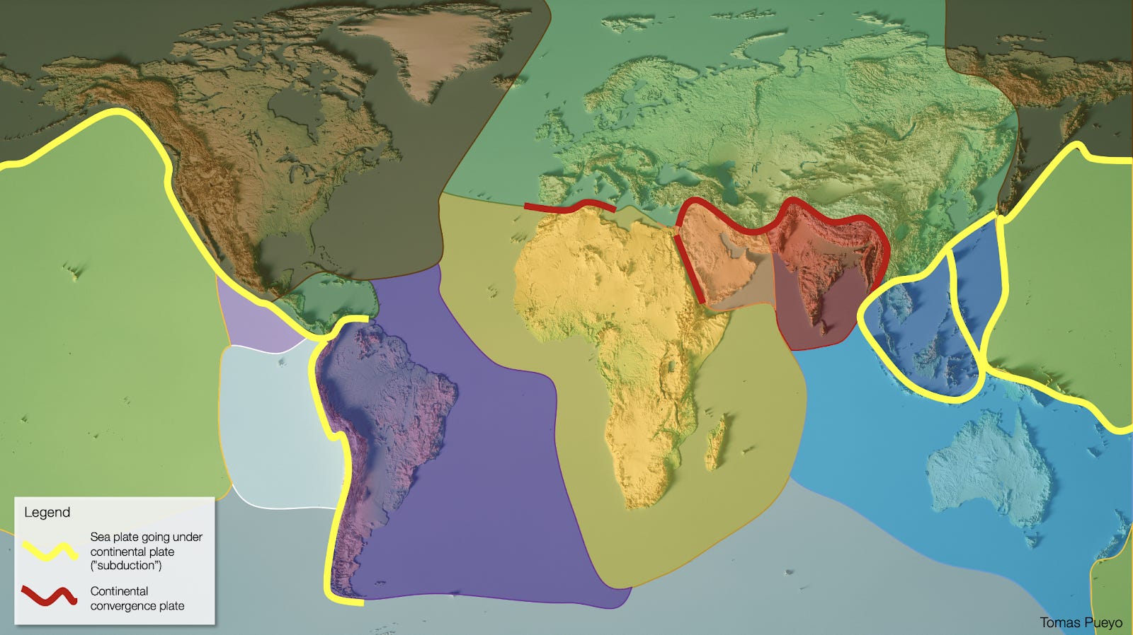
This collision creates the Himalayas, which are the source of the most defining features of both countries.
I mentioned this in A Space-Crafted Chessboard:
Where the Indian plate hits the Eurasian plate, the pressure is so high that it creates the Himalayas, the highest mountain range in the world. The highest mountain range in the world creates the biggest rivers in the world (Indus, Ganges, Brahmaputra, Mekong, Yellow, Yangtze…), which feed the biggest populations in the world—those of the Indian subcontinent, Indochina, and China.
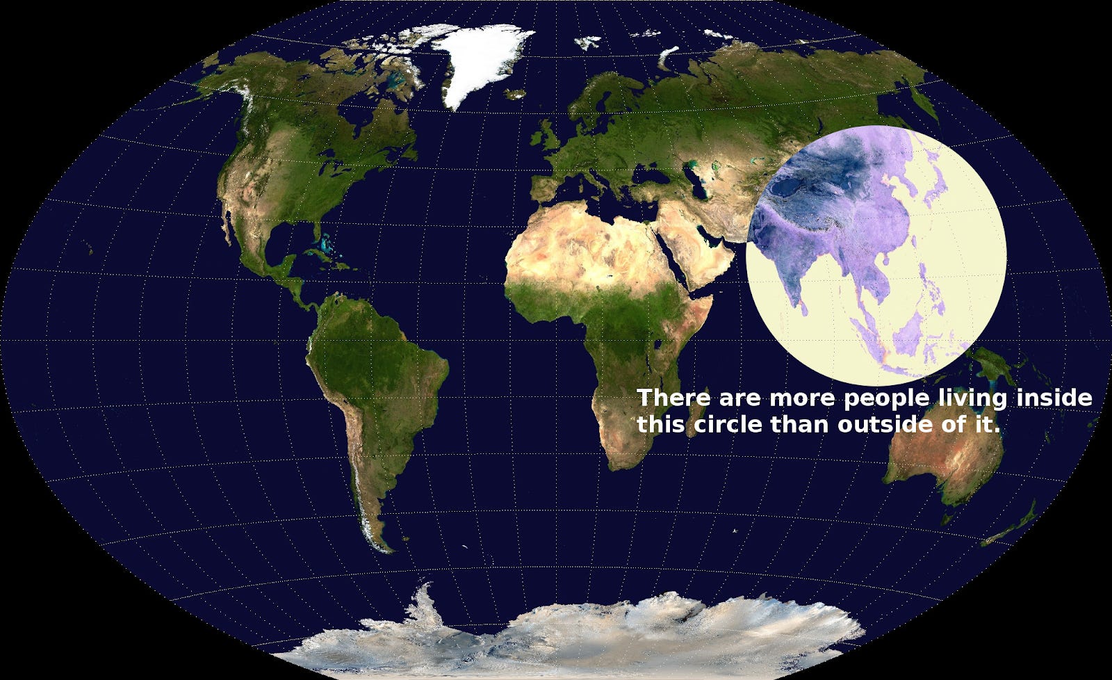
The Valeriepieris map illustrates that well: over half of the world population lives inside that circle. The vast majority of them are the result of water flowing down from the Himalayas.
Continuing, from the article:
Because these rivers come from the Himalayas, they carry so much water. Because of all that water, they bring with them lots of sediments (now you know where the Yellow River’s name comes from). The water and the sediments, together, make the plains they traverse very fertile, which means they can feed huge amounts of populations.
But because they come from the Himalayas, they also grow much bigger in summer, when the temperature goes up and snow melts. That causes river swellings and floods. At the same time, all these sediments cause buildups in the rivers, which when there are floods can dramatically change the course of the rivers, killing millions of people recurrently.
And because of the mountains and the floods and the sediment buildups, all these rivers are very treacherous, making them hard to navigate, so they can’t be so reliably used for communication and trade, which means wealth is harder to build.
I made this video to illustrate the principle for the Ganges Valley. You can see:
The height of the Himalayas
How long they are
How many rivers they produce, all feeding into the Ganges
How many cities are in that valley, enabled by all that fresh water
The rivers of the Ganges valley, full of sandbanks and meanders, making navigation nearly impossible
As I concluded:
So the plate tectonics caused the Himalayas, which caused:
Many massive rivers, and hence the biggest population centers on Earth.
Floods, with their corresponding death and destruction of wealth.
Expensive trade because roads are hard to make and rivers are treacherous, which lowers wealth.
These initial conditions made China and the Indian subcontinent ideal for huge populations to appear very early on. That’s why the first cities appear in the Indus Valley around 2,500 BC, and in China around 1,700 BC.
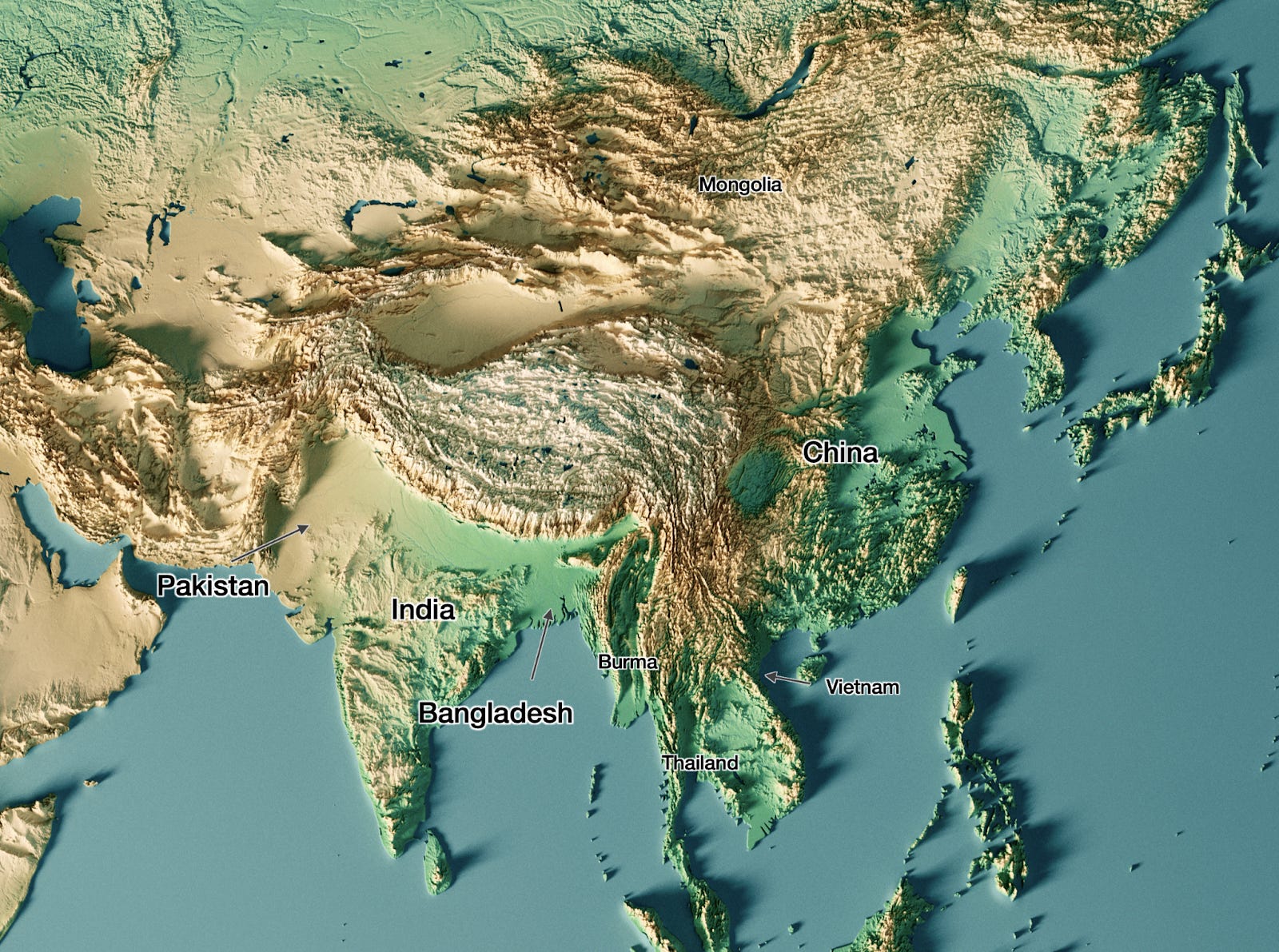
Ok, it’s time to dive deep into each one of the countries. Today, we’ll focus on the Indian Subcontinent: India, Pakistan, Bangladesh, Nepal, and Bhutan.
How Geography Influenced the History of the Indian Subcontinent
Although China and India are very similar, there’s one massive difference between them: whereas China has united most of the area it needs to defend itself, the Indian subcontinent is split in three: India, Pakistan, and Bangladesh. Why?
India and Pakistan are split because of the Aravalli range.
India and Pakistan
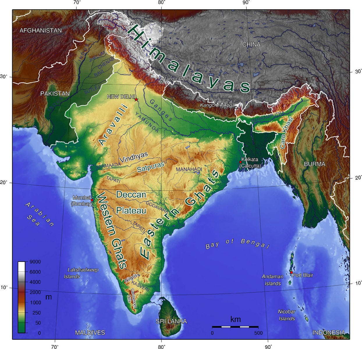
Let’s zoom into the Indian subcontinent.
As usual, look intently. What do you see?
A huge mountain barrier surrounds the subcontinent (Hindu Kush in the West, Himalayas in the North), a result of tectonic plate movements.
Sea surrounds the rest.
India is somewhat mountainous throughout.
The one superflat area is the plain that runs close to the mountains, between the valleys of the Indus and the Ganges.
Sure enough, the valleys of the Indus and Ganges-Brahmaputra are the most populated.
But these valleys are split in two.
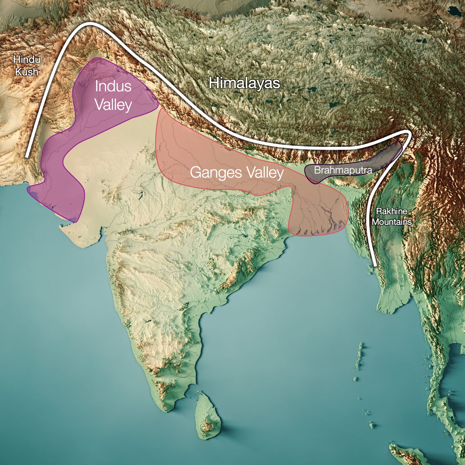
Why? Why don’t both valleys converge in the same place? Because of the Aravalli Range.
This is a range of the oldest mountains in the world, close to Delhi. They form a wedge between the Indus and Ganges, separating their flows, and pushing one to end in the Arabian sea, the other in the Bay of Bengal. As a result, they developed different identities. Today, Pakistan is the Indus Valley, whereas the heartland of India (and Bangladesh) is the Ganges Valley [1] .
Imagine if the Aravalli had been slightly different.
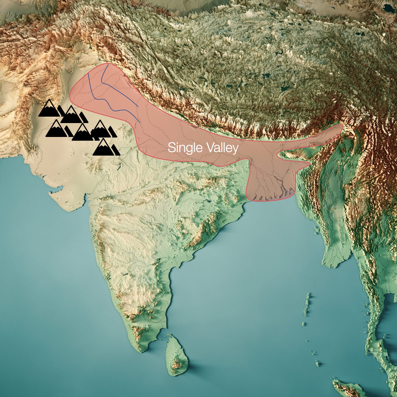
Such a country would have had a single valley with all the water from the Himalayas, forming a single identity, and likely a single country much earlier on. Apparently, this is how India was 5 million years ago. If it had lasted more time geologically speaking, maybe Pakistan wouldn’t exist today.
Instead, the separation between these rivers—the Punjab region—is a flat, short distance, so populated and connected that in fact part of a tributary of the Indus flows through the Indian side. Recipe for conflict.
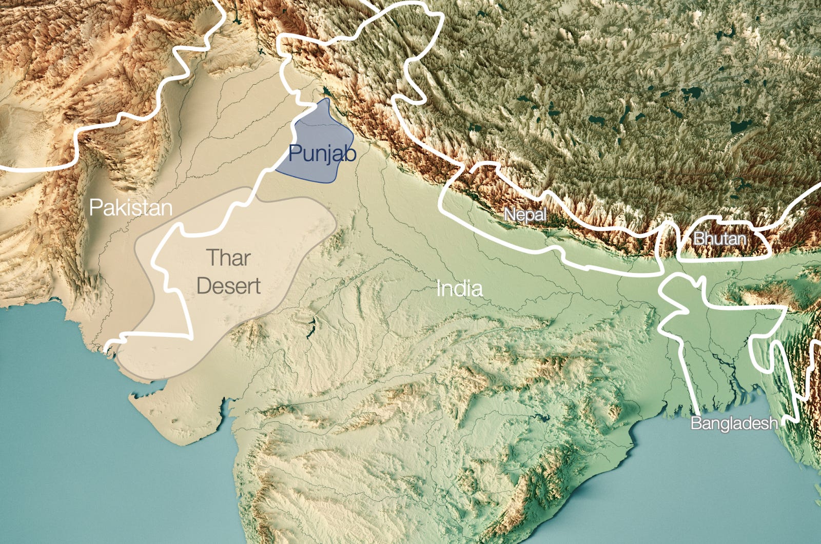
In the south of the Punjab, the rest of the border between Pakistan and India is in the Thar desert, a natural border that is hard to cross, populate, or invade.
In the North, there are the Himalayas, where, despite constant clashes in Kashmir, it’s very hard to progress on either side.
So the natural separation between the Indus and Ganges valleys created different identities and polities. But their connection in the Punjab region connects them. This is why they have different but interconnected histories.
In this video we can see:
Early civilizations occupied either the Indus or the Ganges valleys, but not both.
As time passes, technology improves and unifies the valleys more and more.
Technology also allows armies to conquer more and more of the rest of India: as time passes, bigger swaths of it are unified.
The farther South, the harder it was to unite with the rest of the continent. We’ll get back to that.
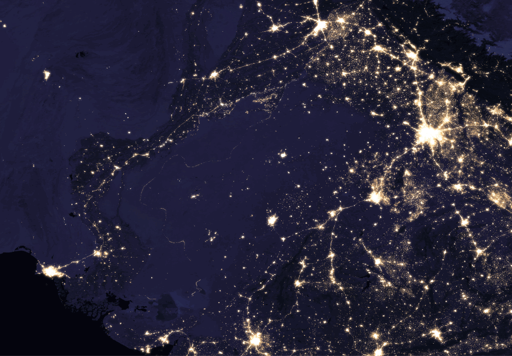
If you were India, in the west you would be obsessed about the fact that a natural unit for your country would include the Indus Valley. Unfortunately for India, that’s Pakistan. And since the two valleys are highly connected by the flat Punjab region, it’s extremely easy to invade. That would make you paranoid about your neighbor, Pakistan.
And that’s why the India-Pakistan border is so guarded—and hence illuminated—that you can see it from space.
To understand better the India-Pakistan politics, we need a small detour on the sea.
India and the Sea Threat
Because the core of the Indian Subcontinent is the valleys of the Indus and Ganges, it is very land-centric. This focus was ok because for most of its history, India never had to worry much about the sea. There were some thalassocracies from the Indonesian archipelago, but that’s the extent of the threat. India itself had a thalassocracy in the Chola Empire, but that’s it. India has been focused all this time on the Indian Subcontinent.
Until the British came.
Like in China, India’s colonial period started because of an invasion from the sea. As a consequence, India is now—and always will be—wary of super-powerful navies that can take control of it.
The super-powerful navy that replaced the British was that of the Americans, after World War II. That made them prime candidates to try to replace the Brits. India, knowing this, was not very friendly to the US for decades. The US, ambivalent about their aims with regards to India, didn’t help.
So India needed friends. Who was an enemy of the US that would want to help? The Communists. China, being a threatening neighbor, was not a good candidate for friendship. But the Soviet Union was: they were separated by impenetrable mountains, so they weren’t a threat.
And that’s perfect, because the Soviet Union is close to Afghanistan. Which is the neighbor of your mortal enemy, Pakistan. So you would be very happy if your friend the Soviet Union would invade Afghanistan, surrounding Pakistan with threats.
And Pakistan would hate that, so they would try to find whatever strong friend they could find. One of them is China today. Another was the US: the US was enemies with the Soviet Union and not very friendly with India, so it made sense for the US to prop up Pakistan.
And this is how you end up with the most powerful—and Christian-inspired—democracy on earth (the US) supporting a Muslim dictatorship (Pakistan) against the biggest democracy in the world (India), which in turn was friend with a Communist dictatorship (the Soviet Union).
Let’s turn to the other side now, the east of the Indian Subcontinent.
Eastern India
These are the borders of the countries in the Indian Subcontinent:
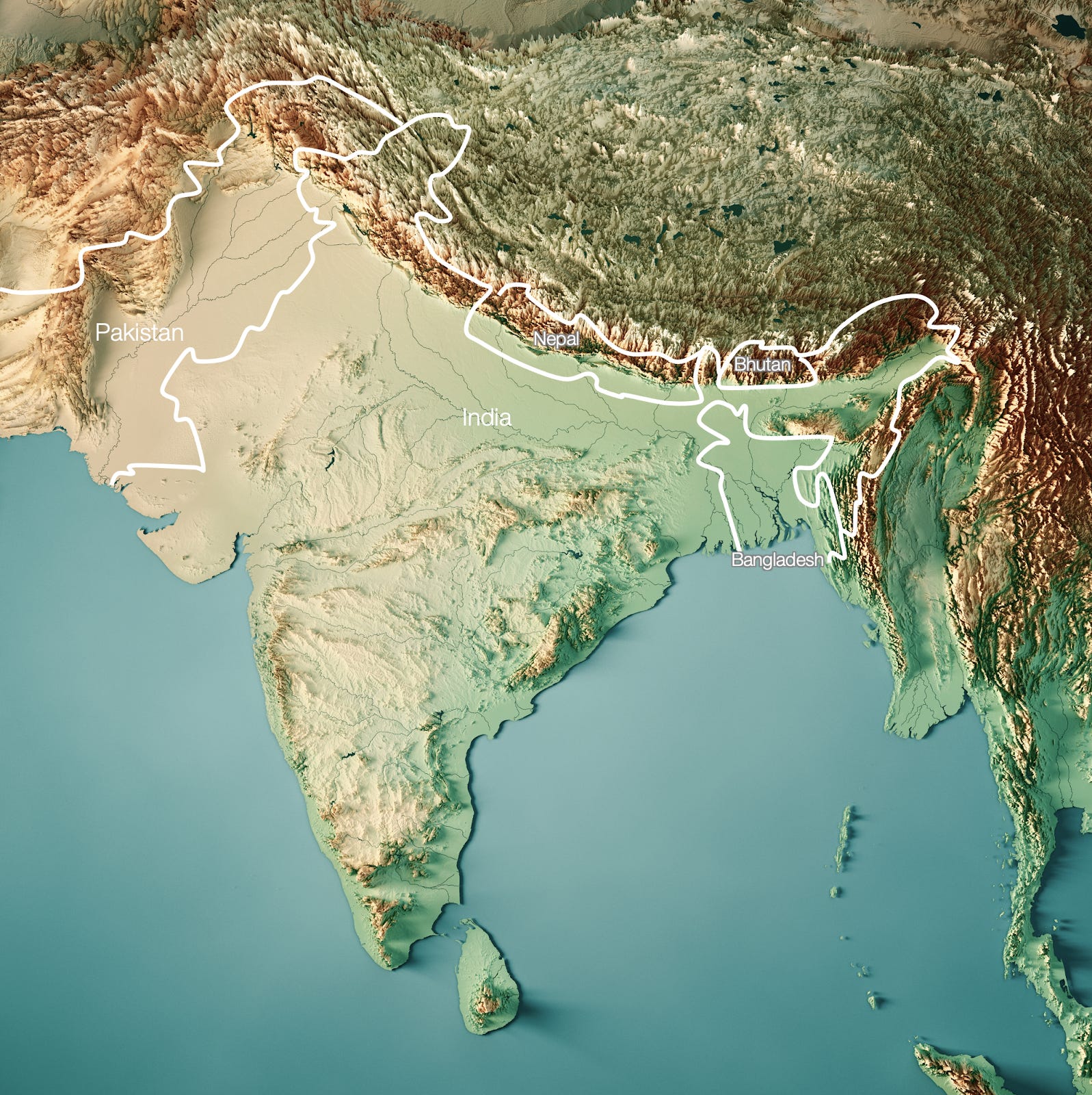
Eastern India is defined by Bangladesh. Bangladesh exists because it has a majority of Muslims. That was the main criterium for border drawing during India’s independence process, so Bangladesh became part of Pakistan when India was partitioned. Why does that region have a majority of Muslims though, but not the rest of the Ganges Valley?
From what I can gather, the best explanation is that the region that is today Bangladesh—East Bengal— was heavily Buddhist. But Buddhism was persecuted and penalized. When Muslim merchants appeared—and, later, Muslim rule—the oppressed Buddhists were more open to an alternative to Hinduism than any other social group. Islam took a stronger root there [2] .
From the Indian perspective, having the mouth of your most important region controlled by another state is inconvenient. But at least Bangladesh is surrounded, so they have more control over it than over Pakistan. Hence it’s less worrying.
Farther east, you have Burma, but the Rakhine mountains separating it from India have intense jungle. Mountainous jungle is very hard to traverse, and I can’t find a single event in history where India was invaded from that way. That’s why the Rohingya population escaping Burma is so poor to begin with. On top of this, Burma is very poor right now. There’s no threat for India there right now.
The Himalayas: India, China, and their buffer states Nepal and Bhutan
India and China look more hostile against each other than they really are. The Himalaya completely separates them.


Without population or resources, being hard to build on, and far away from the Chinese heartland, it’s very hard to station an army in Tibet. Not a single Indian invasion came this way in history.
Just to make sure, China and India have the buffer states of Bhutan and Nepal, which are not only hyper mountainous, but also landlocked, so they are doomed to be poor and weak. Perfect as buffers, terrible for their populations.
Nevertheless, India and China like destabilizing each other to make sure nobody takes too much advantage in that area. That’s why China took Tibet, why India supports an independent Tibet, why India considers Nepal its sidekick, and why China supported a Maoist movement there for decades.
Indian Foreign Policy Today
Summarizing, the Indian Subcontinent is an island, partitioned in three, where most of the island is occupied by the giant India.
Bangladesh, Burma, Bhutan and Nepal aren’t too worrisome. China is too well separated by the Himalayas. The one big problem is India–Pakistan.
The botched partition, broadly along religious lines, exposes India to Pakistan and vice-versa. They are meant to obsess over each other. So far, they have translated that into enmity.
Also, because Pakistan is Muslim while India is mostly Hindu, that’s perfect ground for a populist to appear and use religion to increase tension with Pakistan and unite India at the same time.
Meanwhile, Pakistan sees the exact same thing, but in reverse. The bigger neighbor, with much more and more fertile land, sees you as the natural extension of their country, which is extremely easy to invade. Knowing that India wants to destabilize you, you’d want to protect yourself (nuclear weapons), destabilize India (religion), and befriend their potential enemies (the US, China).
I hope that one day, like France and Germany, they unite rather than fight.
India Internally
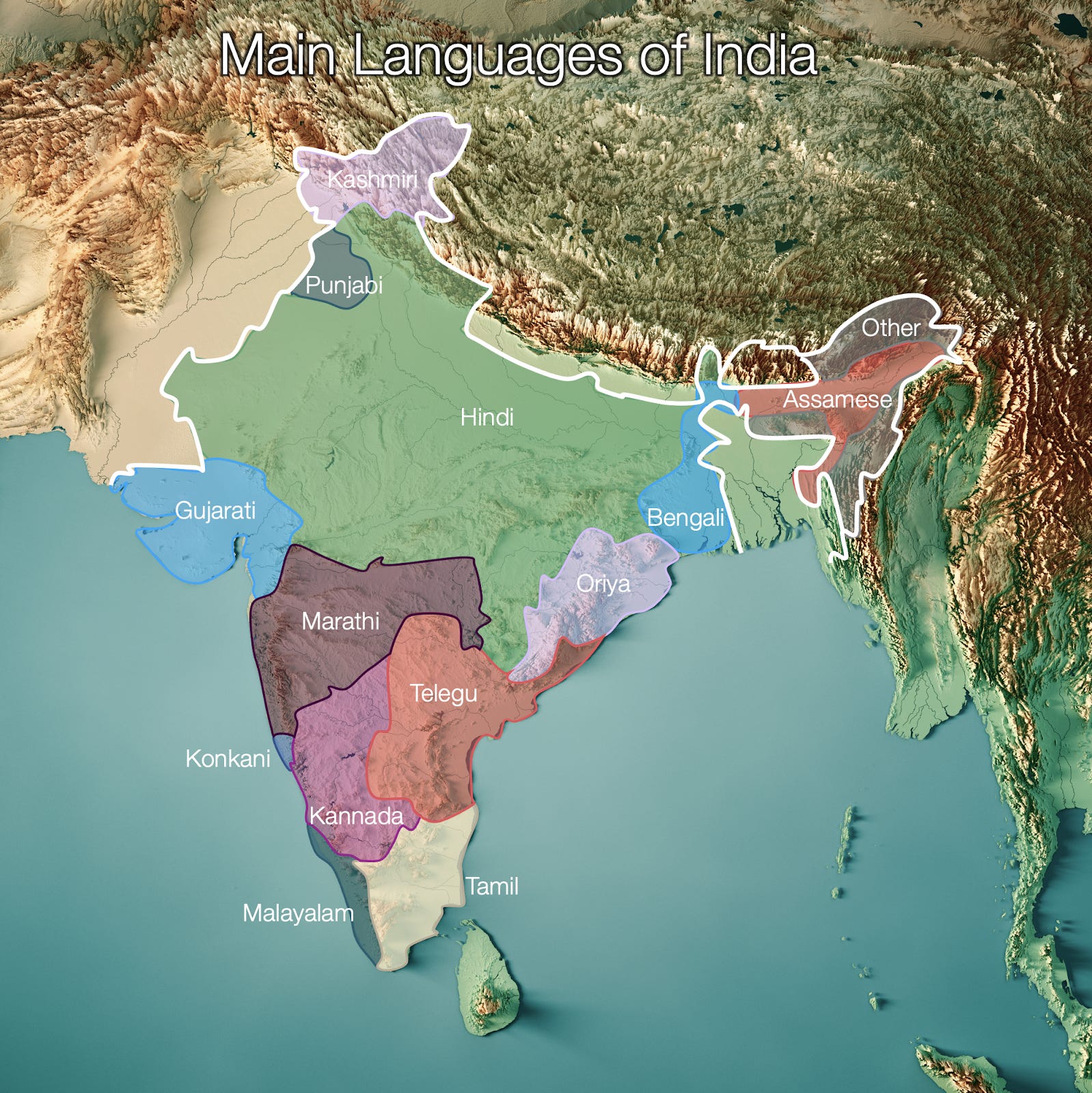
India has hundreds of languages, but these are the main families.
Hindi, the most common language, is unsurprisingly the language of the Ganges Valley. Outside of that, most languages correspond to geographic areas.
Bengali is spoken in the Bay of Bengal, and also in Bangladesh.
Assamese corresponds to the Brahmaputra Valley.
Kashmiri to the Himalayas.
Punjabi to the special border region with the Indus Valley.
Gujarati is spoken in Gujarat, an area of plains separated from the rest of regions by the Indus Valley in the west, the Thar desert in the north, and mountains to the east.
Malayalam is spoken in the small strip between the ocean and the Western Ghat mountains.
Tamil is spoken in the plains area east of the Ghats.
And so on.
Rivers and valleys defined the major identity and language borders of India.
But these internal borders are much weaker than in Europe:
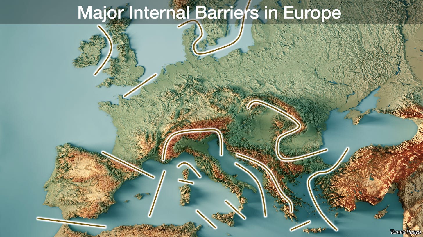
That’s probably why identities are more different between countries in Europe than between regions in India. It’s also why empires were much more fluid in India than they were in Europe, where nations such as France, Spain, Portugal, and Great Britain where already formed 500 years ago.
The right level of comparison for India is not with any single European country then, but with Europe as a whole. While India is much more unified identity-wise than Europe, it’s also much less unified than any single European country. That’s why Indian regions are strong and independent, why there are regional tensions inside of India, and why managing these tensions is a core focus of any Indian government.
Takeaways
The Indian Subcontinent is an island separated by seas, insurmountable mountains, and jungle.
India and Pakistan share that island, so they’re forced to interact. They will be aggressive enemies until they become strong allies, which is possible, because countries like France and Germany or the US and Mexico have shown it’s possible. In both cases though, one of the countries had to prevail over the other. That’s impossible in a nuclear world. It’s also hard when not sharing a religion.
Bangladesh also shares the island, but being a smaller country surrounded by India, it’s less of a threat to India.
India and China are well separated. They have buffer states in Tibet, Nepal, and Bhutan. India feels secure with that arrangement, as it should.
Burma is separated by mountains and jungle and is extremely poor and weak. Not a threat.
The rest is sea. India will be able to focus on it more, but only if it can grow its economy more and if the threat coming from the India-Pakistan border disappears. The US—and China—have no incentive to see a strong naval India, so they’re likely to keep supporting Pakistan.
Internally, India has regions broadly defined by its rivers and mountains, which can be seen in the languages spoken today. This determines its internal politics, which suffer from regionalism with a strong push by the central government to unite the country.
There’s obviously so much more to say about India, but this clearly shows how the biggest political dynamics in the country are rooted in geography. So let’s stop here. China is coming next. I hope you enjoyed!
And the Brahmaputra Valley too, albeit secondary.
But who knows. Not me! If you do know, please tell me!